General information about this notebook
This notebook series has been initiated by the Data Management Project (INF) within the TR-172 “ArctiC Amplification: Climate Relevant Atmospheric and SurfaCe Processes, and Feedback Mechanisms” (AC)³ funded by the German Research Foundation (Deutsche Forschungsgemeinschaft, DFG)
Author(s) of this notebook:
Johannes Röttenbacher, Leipzig Institute for Meteorology, Stephanstraße 3, 04103 Leipzig, johannes
.roettenbacher@uni -bremen .de
GitHub repository: https://
This notebook is licensed under the Creative Commons Attribution 4.0 International
Dataset description
Title: Aircraft measurements of spectral downward solar irradiance over Arctic sea ice and ocean during the HALO-(AC)³ campaign in spring 2022
Authors: Röttenbacher, Johannes; Ehrlich, André; Schäfer, Michael; Kirbus, Benjamin; Luebke, Anna E; Wendisch, Manfred
Description: During the HALO-(AC)³ campaign in March and April 2022 spectral solar downward irradiances were measured onboard of the High Altitude LOng range research aircraft (HALO) over the Arctic sea ice and ocean using the Spectral Modular Airborne Radiation measurement sysTem (SMART). The data set gives time series of spectral irradiances measured along the flight path of HALO on 17 days. All flights started from Kiruna, Sweden and headed into the Fram Straight and towards the central Arctic. The goal of the campaign was to study warm air intrusions and cold air outbreaks to and from the Arctic and to follow those air masses over several days with remote sensing instrumentation aboard HALO. The first research flight (RF) was RF02. RF01 was the transfer flight from Oberpfaffenhofen, Germany to Kiruna. The irradiance inlet of SMART was actively stabilized and connected to two spectrometers of which one measured radiation in the visible to near infrared range (VNIR) between 180 and 1014 nm and the other radiation in the shortwave to infrared range (SWIR) between 890 and 2200 nm. The data was merged at 990 nm and cut to 320 to 2100 nm because of high uncertainties at the spectrometer edges. The spectral resolution below 900 nm is 1nm and above 5 nm due to technical limitations of the SWIR spectrometer. The data is corrected for the dark current of the spectrometers and calibrated using in field transfer calibrations connected to a laboratory calibration after the campaign.
Year: 2023
Institutes: Leipzig Institute for Meteorology, Deutsches Zentrum für Luft- und Raumfahrt (DLR)
DOI: Röttenbacher et al. (2023)
License: Creative Commons Attribution 4.0 International
Contents of this notebook
Read in calibrated SMART data, plot it on a map and compare to a clear sky simulation provided within the dataset.
import matplotlib.pyplot as plt
import numpy as np
import pangaeapy as pgp
import xarray as xr
# needed for parallel download of data
import nest_asyncio
nest_asyncio.apply()
Research Flight 17 - 2022-04-11
# data from PANGAEA (saved to local cache defined in "~/.config/pangaeapy/config.toml"
# Experimental using the dev branch of pangaeapy
ds = pgp.PanDataSet(956151, enable_cache=True)
filenames = ds.download(indices=[15], columns=['Binary'])
[INFO] Cache directory set to: E:\tmp\pangaeapy_cache
[INFO] To change the cache directory permanently, edit: C:\Users\Johannes\.config\pangaeapy\config.toml
Downloading files to E:\tmp\pangaeapy_cache
Available files
Binary \
0 HALO-AC3_HALO_SMART_spectral-irradiance-Fdw_20...
1 HALO-AC3_HALO_SMART_spectral-irradiance-Fdw_20...
2 HALO-AC3_HALO_SMART_spectral-irradiance-Fdw_20...
3 HALO-AC3_HALO_SMART_spectral-irradiance-Fdw_20...
4 HALO-AC3_HALO_SMART_spectral-irradiance-Fdw_20...
5 HALO-AC3_HALO_SMART_spectral-irradiance-Fdw_20...
6 HALO-AC3_HALO_SMART_spectral-irradiance-Fdw_20...
7 HALO-AC3_HALO_SMART_spectral-irradiance-Fdw_20...
8 HALO-AC3_HALO_SMART_spectral-irradiance-Fdw_20...
9 HALO-AC3_HALO_SMART_spectral-irradiance-Fdw_20...
10 HALO-AC3_HALO_SMART_spectral-irradiance-Fdw_20...
11 HALO-AC3_HALO_SMART_spectral-irradiance-Fdw_20...
12 HALO-AC3_HALO_SMART_spectral-irradiance-Fdw_20...
13 HALO-AC3_HALO_SMART_spectral-irradiance-Fdw_20...
14 HALO-AC3_HALO_SMART_spectral-irradiance-Fdw_20...
15 HALO-AC3_HALO_SMART_spectral-irradiance-Fdw_20...
16 HALO-AC3_HALO_SMART_spectral-irradiance-Fdw_20...
IMAGE
0 HALO-AC3_SMART_calibrated-Fdw_quicklook_202203...
1 HALO-AC3_SMART_calibrated-Fdw_quicklook_202203...
2 HALO-AC3_SMART_calibrated-Fdw_quicklook_202203...
3 HALO-AC3_SMART_calibrated-Fdw_quicklook_202203...
4 HALO-AC3_SMART_calibrated-Fdw_quicklook_202203...
5 HALO-AC3_SMART_calibrated-Fdw_quicklook_202203...
6 HALO-AC3_SMART_calibrated-Fdw_quicklook_202203...
7 HALO-AC3_SMART_calibrated-Fdw_quicklook_202203...
8 HALO-AC3_SMART_calibrated-Fdw_quicklook_202203...
9 HALO-AC3_SMART_calibrated-Fdw_quicklook_202203...
10 HALO-AC3_SMART_calibrated-Fdw_quicklook_202204...
11 HALO-AC3_SMART_calibrated-Fdw_quicklook_202204...
12 HALO-AC3_SMART_calibrated-Fdw_quicklook_202204...
13 HALO-AC3_SMART_calibrated-Fdw_quicklook_202204...
14 HALO-AC3_SMART_calibrated-Fdw_quicklook_202204...
15 HALO-AC3_SMART_calibrated-Fdw_quicklook_202204...
16 HALO-AC3_SMART_calibrated-Fdw_quicklook_202204...
File HALO-AC3_HALO_SMART_spectral-irradiance-Fdw_20220411_RF17_v1.0.nc already exists, skipping.
ds = xr.open_dataset(filenames[0])
dsds['Fdw_int'] = ds.Fdw_cor.integrate('wavelength')
ds['Fdw_sim_int'] = ds.Fdw_simulated.integrate('wavelength')import cartopy.crs as ccrs
fig, ax = plt.subplots(subplot_kw=dict(projection=ccrs.NorthPolarStereo()))
ax.set_extent([-30, 30, 60, 90])
ax.coastlines()
gl = ax.gridlines(draw_labels=True)
gl.top_labels = False
# scale the colorbar only to the 90th percentile to exclude outliers
vmax = np.percentile(ds.Fdw_int[~np.isnan(ds.Fdw_int)], 90)
fwd = ax.scatter(ds.lon, ds.lat, c=ds.Fdw_int, transform=ccrs.Geodetic(), vmin=0, vmax=vmax)
fig.colorbar(fwd, ax=ax, label='Integrated downward irradiance (W$\\,$m$^{-2}$)')
plt.show()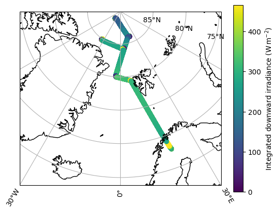
_, ax = plt.subplots()
ds['Fdw_int'].plot(x='time', ax=ax, label='Measurement')
ds['Fdw_sim_int'].plot(x='time', ax=ax, label='Simulated')
ax.legend()
ax.grid()
ax.set(
    ylabel='Integrated solar downward irradiance (W$\\,$m$^{-2}$)',
    xlabel='Time (UTC)',
)
plt.show()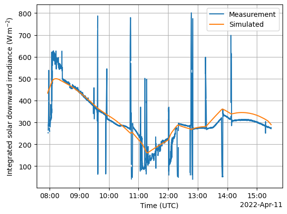
There is a stabilization flag in the data, which should help us filter out the unnatural peaks in the measurement data.
_, ax = plt.subplots()
ds['Fdw_int'].where(ds['stabilization_flag'] == 0).plot(x='time', ax=ax, label='Measurement')
ds['Fdw_sim_int'].plot(x='time', ax=ax, label='Simulated')
ax.legend()
ax.grid()
ax.set(
    ylabel='Integrated solar downward irradiance (W$\\,$m$^{-2}$)',
    xlabel='Time (UTC)',
)
plt.show()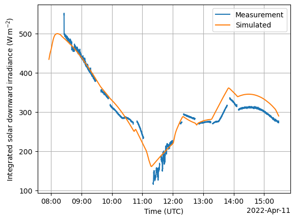
- Röttenbacher, J., Ehrlich, A., Schäfer, M., Kirbus, B., Luebke, A. E., & Wendisch, M. (2023). Aircraft measurements of spectral downward solar irradiance over Arctic sea ice and ocean during the HALO-(AC)3 campaign in spring 2022. PANGAEA. 10.1594/PANGAEA.956151